


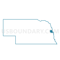
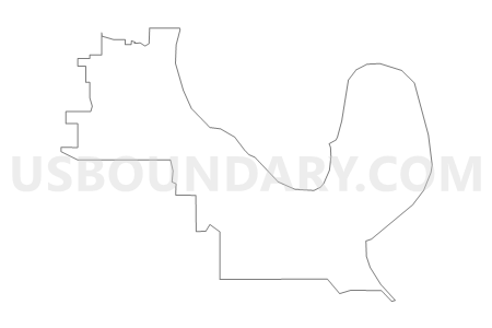
Northview Precinct, Washington County, Nebraska
About
Outline

Summary
| Unique Area Identifier | 613999 |
| Name | Northview Precinct |
| County | Washington County |
| State | Nebraska |
| Area (square miles) | 19.41 |
| Land Area (square miles) | 18.48 |
| Water Area (square miles) | 0.93 |
| % of Land Area | 95.22 |
| % of Water Area | 4.78 |
| Latitude of the Internal Point | 41.51385100 |
| Longtitude of the Internal Point | -96.06979020 |
Maps


Graphs
Select a template below for downloading or customizing gragh for Northview Precinct, Washington County, Nebraska


Neighbors
Neighoring Voting District (by Name) Neighboring Voting District on the Map
- Arbor Precinct, Washington County, NE
- Blair - Central S3-W3 Voting District, Washington County, NE
- Blair - Dexters S4-W4 Voting District, Washington County, NE
- Blair - Skyline S3-W2 Voting District, Washington County, NE
- CINCINNATI TWP Voting District, Harrison County, IA
- Desoto Precinct, Washington County, NE
- Fort Calhoun East Precinct, Washington County, NE
- ROCKFORD TWP Voting District, Pottawattamie County, IA
Top 10 Neighboring County Subdivision (by Population) Neighboring County Subdivision on the Map
- Blair city, Washington County, NE (7,990)
- Township 1, Washington County, NE (3,894)
- Township 2, Washington County, NE (2,854)
- Township 5, Washington County, NE (1,294)
- Rockford township, Pottawattamie County, IA (632)
- Cincinnati township, Harrison County, IA (197)
Top 10 Neighboring Place (by Population) Neighboring Place on the Map
Top 10 Neighboring Unified School District (by Population) Neighboring Unified School District on the Map
- Blair Community Schools, NE (13,117)
- Missouri Valley Community School District, IA (5,332)
- Fort Calhoun Community Schools, NE (3,014)
Top 10 Neighboring State Legislative District Lower Chamber (by Population) Neighboring State Legislative District Lower Chamber on the Map
Top 10 Neighboring State Legislative District Upper Chamber (by Population) Neighboring State Legislative District Upper Chamber on the Map
Top 10 Neighboring 111th Congressional District (by Population) Neighboring 111th Congressional District on the Map
Top 10 Neighboring Census Tract (by Population) Neighboring Census Tract on the Map
- Census Tract 501.02, Washington County, NE (5,177)
- Census Tract 502.01, Washington County, NE (3,965)
- Census Tract 214, Pottawattamie County, IA (3,589)
- Census Tract 502.02, Washington County, NE (3,165)
- Census Tract 2905, Harrison County, IA (2,522)